The Great Gomez

Updated: 1 hour ago

Let's again leave behind all the hoopla about tight oil and shale gas for a few minutes, please, and visit a very important gas discovery that occurred in Pecos County in West Texas in 1963, just north of the town of Fort Stockton.
It is a milestone in Texas oil and gas industry history and one I hope you will find interesting. As a Texan, I am proud to write it.
"There is no oil west of the Pecos River; I will drink all the oil ever found over there."
Unknown Oilman, Midland; 1921.

A bad bet that was.
Oil was first discovered in significant amounts in Pecos County on Ira Yates' ranch in the shallow, San Andres (1,000 feet) down in the S.E part of the county in 1926. Michael Benedum and Joe Trees made that discovery with a cable tool rig and total well costs were $13,000. The well came in for 400 BOPD, cleaned up and was later gauged to make 3,400 BOPD.
The rest is history, of course, and Yates Field will ultimately produce 2.2 G BO from the San Andres and Grayburg, currently operated by Kidder Morgan and under CO2 EOR.
A red hay barn on Mr. Yate's ranch, near the discovery well, became a boom town, with thousands of oilfield workers moving in to erect wooden derricks and drill wells as fast as they could get them drilled. The make-shift tent town became known as Red Barn.
Mr. Yates became a little irritated at all the activity around his horses, so he deeded 154 acres of land on the northeast end of the ranch, against the Pecos River, and made the entire town move up there. The town was called Irran.

About the same time Yates Field was being developed, commercial oil volumes were being found to the east, on the Central Platform, in Crane and western Upton Counties. These wells were targeting deeper Devonian pays and finding terrific porosity and wells that flowed massive amounts of oil.
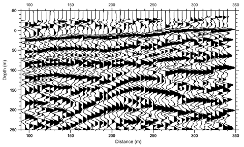
After being used successfully along the Texas Gulf Coast in 1922, reflection seismic lines started to be shot in the hard rocks of the Permian Basin with good success. Stress induced anticlines and folds stuck out like sore thumbs at shallow depths. A large two-dimensional (2-D) series of strike and dip lines were shot on a large grid pattern in Southern Crane and Upton Counties, and northern Crockett in 1926-1927 and traversed the Pecos River over into Pecos County, but the data stopped miles east of Fort Stockton and left geologists stumped. longing for more.
Deeper markers in the Devonian and Simpson formations appeared to be getting higher along an anticlinal ridge line, show the seismic showed. Geologists with Gulf Oil projected the apex of the ridge line going west right under Fort Stockton and turning northwest. Dip meters in shallow wells drilled in the area helped speculate on the possibility of a regional high. But it was deep, and hot, expensive to drill and assumed to be gassy because of depth. Nobody pursued the idea of a deep well near Fort Stockton.


If one clicks the structure map on the left it follows the cross section on the right and west of Fort Stockton deep Cambrian beds fall of an old reef edge into a deep trough throughout the Delaware Basin. The basement in this trough (dark brown) is near 30,000 feet below sea level.

In June of 1962 Pure Oil Company, Pittsburg, PA, in cahoots with Gulf Oil, spudded the W.C. Tyrell No. 1 well nine miles N.W. of downtown Fort Stockton. The structure they found eventually became part of something called the Fort Stockton Uplift.
Pure Oil drill stem tested good gas flows from the shallow Bone Springs, set an intermediate string of 9 5/8ths OD casing across that and carried on. It found the top of the Ellenburger Dolomite at appx. 19,600 feet. Two different intervals in the Ellenburger were drill stem tested at various rates estimated to be upwards of 13 MMFGPD; the gas was low BTU and had no water with it to speak of. Five strings of casing were set, the well took one year to drill and was TD with 4 1/2 in. OD production casing set to 21,063 feet TMD.
The No. 1 well was marginal and never paid back its $1.5 MM drilling and completion costs. The Pure No. 2 Tyrell was drilled in 1964 a few thousand feet away from the No. 1 to the Ellenburger and it IP'd for 65 MM c.f. gas per day on small chokes. The field was named, Gomez, a takeoff on the name, Gulf Oil.
The Ellenburger formation is the end of the road in the Permian Basin, in both sub-basins, and igneous rock basement is immediately below it. Its deposition has a hydraulic component (water) as the interval can be 1,200 foot thick but is almost vugular in porosity. Some porosity in the Ellenburger is reported to be over 23% with 100 millidarcies of permeability!
Solution of Ellenburger carbonates during deposition left karst like rock and drilling reports were always mentioning 10-20 foot drill breaks like they had drilled into caverns. The bottom hole temperature in Gomez is 330 degrees F and BHP is 10,275 PSI. The drive mechanism for the Ellenburger is solution gas but there is a definite hydraulic component that explains minimal loss in BHP over the years. The productive limits of the field are about 23,000 acres.


Multiple operators jumped in the fray in the mid 1960s and 1970s, like Mobile, Humble, Socony, Pan American, Texaco and Jake Hammon. By 1980, 110 wells were producing 188 MMCFGPD, all on 640-acre well densities and under strict TRRC proration schedules designed for maximum recovery of gas in place. Imagine that!


A word about Gomez well costs in the mid to late 1960's, please: After its discovery in 1963 leasehold bonuses shot up to an unheard-of amount of $20-25 per net acre suggesting one 640-acre section might have cost $14,000. Diamondback, you recall, paid Endeavor $4.6 MM per 1,200 acre DU, Matador in Lea County was upwards of 6.5 MM dollars per location.
With four strings of casing and some small, staged acid jobs I estimate these wells cost $1.2 MM to drill and complete until costs started escalating in the early 1980s. By 1983 average time to drill a 21,000 foot GOMEZ well had declined to less than 160 days.


Gomez produced 4.35 TCF of natural gas to 1993 and an estimated 59,618,761 MCF from Y.E 1993 to March 2026; its cumprod. to date therefore is around 5 TCF. It's believed the field will produce at least another 20 years and ultimately make 6.3 TCF.

Gomez Gas Field in Pecos County to this day represents the largest single collection of wells producing below 20,000 feet TVD in Texas.
Comanche Springs, Pecos County
Army outposts were not built in the vast frontier, like West Texas, unless they were located near water. And so it was with Fort (Camp) Stockton, built along the Comanche and Leon Springs of Pecos County in 1860. The water was cold, and clear, and clean and bubbled up out of the ground from the Edwards formation, the same massive groundwater aquifer that we drink our water from in San Marcos, 580 miles to the east. The area around Camp Stockton was literally an oasis in the middle of an arid desert.


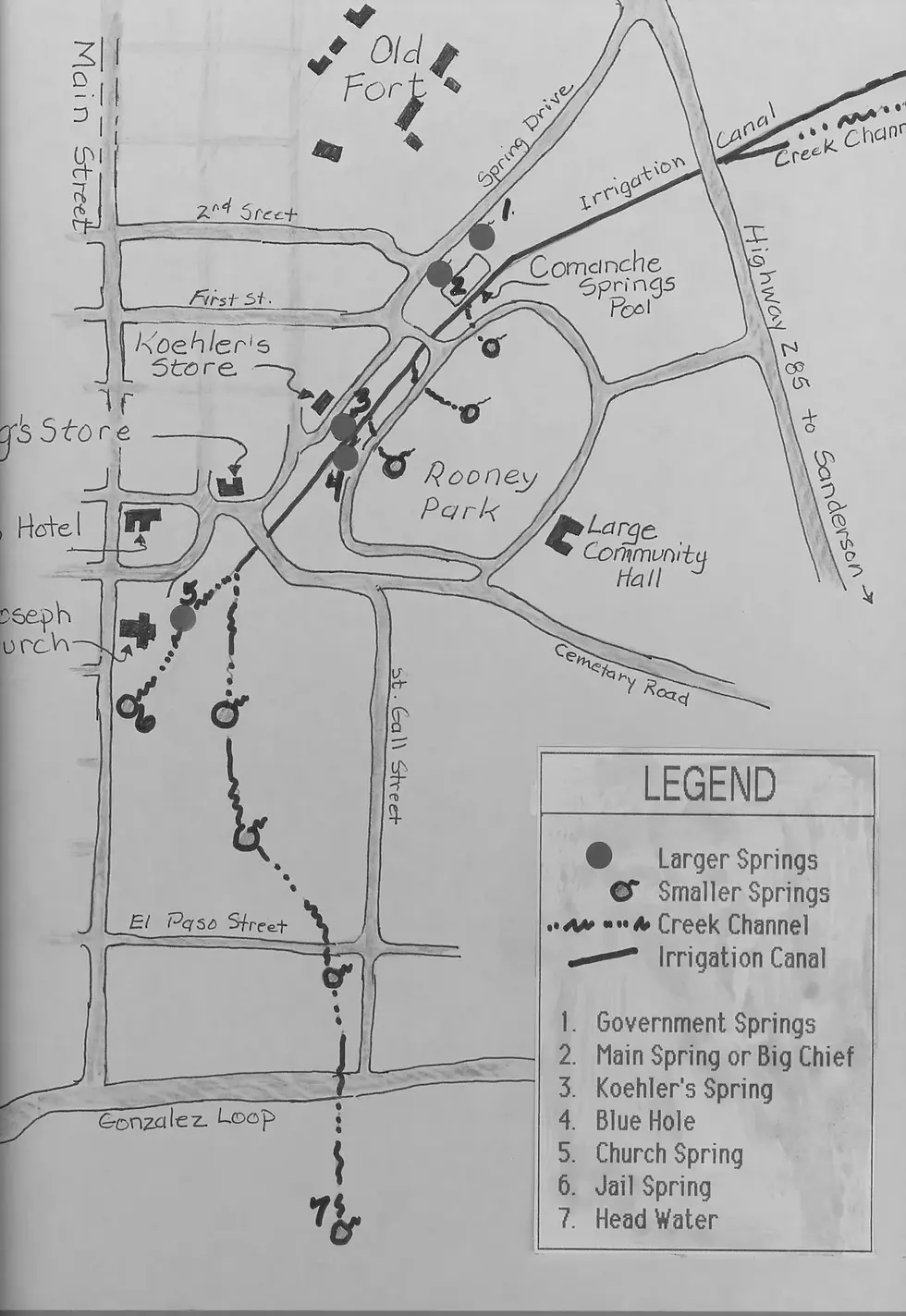
By the early 1880's wealthy merchants and cattle ranchers from the San Antonio area began buying large tracts of land near Fort Stockton to irrigate crops with. It was hot country, the soil not very good and various crops failed consistently. Big ranchers in the area drilled deeper wells for more irrigation in the 193os and 1940's and water withdrawal from the Edwards and Trinity aquifers reached an estimated 45 MM gallons per day.
Water levels began to decrease and flow rates from the springs slowed drastically. The Pecos County Water District filed a lawsuit against the biggest "pump farmer" in the area, Clayton Williams, Sr., to cease draining the aquifer on behalf of hundreds of families that relied on the springs for their water.


By 1954 the Texas Court of Appeals ruled in favor of Mr. Williams and upheld the Texas Supreme Court's decision that groundwater belonged to the surface estate and the rule of capture prevailed. Mr. Williams and others defiantly drilled bigger irrigation wells, for the most part to grow hay to feed their cattle.
By the mid 1960's Comanche Springs was virtually drained dry and flow from the springs ceased completely.
The author, Gunar Brune called the draining of Comanche Springs a spectacular example of man's abuse of nature. Far more spectacular examples of groundwater abuse, however, began to occur all over West Texas in 2012-2015.
Author's note: I enjoy researching these sorts of things on 100 degree days in S. Texas and writing about them in my cool office. It is how I learn and how I am reminded about how true wildcatting helped make America become the greatest economic powerhouse the world has ever known with inexpensive, abundant oil and natural gas.
As I kid in 1972-1973 I roughnecked a deep Ellenburger well in south Pecos County; I don't remember who it was for nor who my employer was; I want to say it was Cactus. Or H&P; the rig had a 25 foot floor on it and its underbelly was full of BOP stack. I remember it was freezing cold that winter and every norther that blew thru West Texas carried sleet, snow and freezing rain with it and it was warmer in Wyoming that winter than Pecos County. Every bit trip we made on that well with 1oo degree drill pipe coming out of the hole (350 degree BHP) made it bearable up in the racking board at 3 in the morning, soaking wet.
Pisano Pete is the name of the Road Runner in Fort Stockton. They are amazing birds in many ways, the males beautiful with bright orange cheeks. In Spanish they are called Chaparral and they will make a rattlesnake die a terrible death before being laid out on a rock, lightly toasted, then eaten.
References
Bureau of Economic Geology
Oil and Gas Journal
One Petro
B.W. Schumacher; Paper Number: SPE-49221-MS
Ellenburger Group Permian | Kingdom Exploration Review
AAPG Publications
Portal to Texas History
North Texas University Digital Library
Permian Basin Petroleum Museum
Texas State Historical Association
Pecos County Historical Society
Research Gate
New York Times
Comments